
In a world dominated by image, it weighs heavily when planning a trip. Who has not been seduced by a landscape and has programmed everything to be there? Beyond the things we can buy, the views, the landscapes, the experiences, are what motivates us to travel. Those moments suspended in our personal timeline.
So let's see today the most beautiful landscapes in the world. Perhaps you are lucky and have already personally met some. Or not?
Kirkjufell Mountain
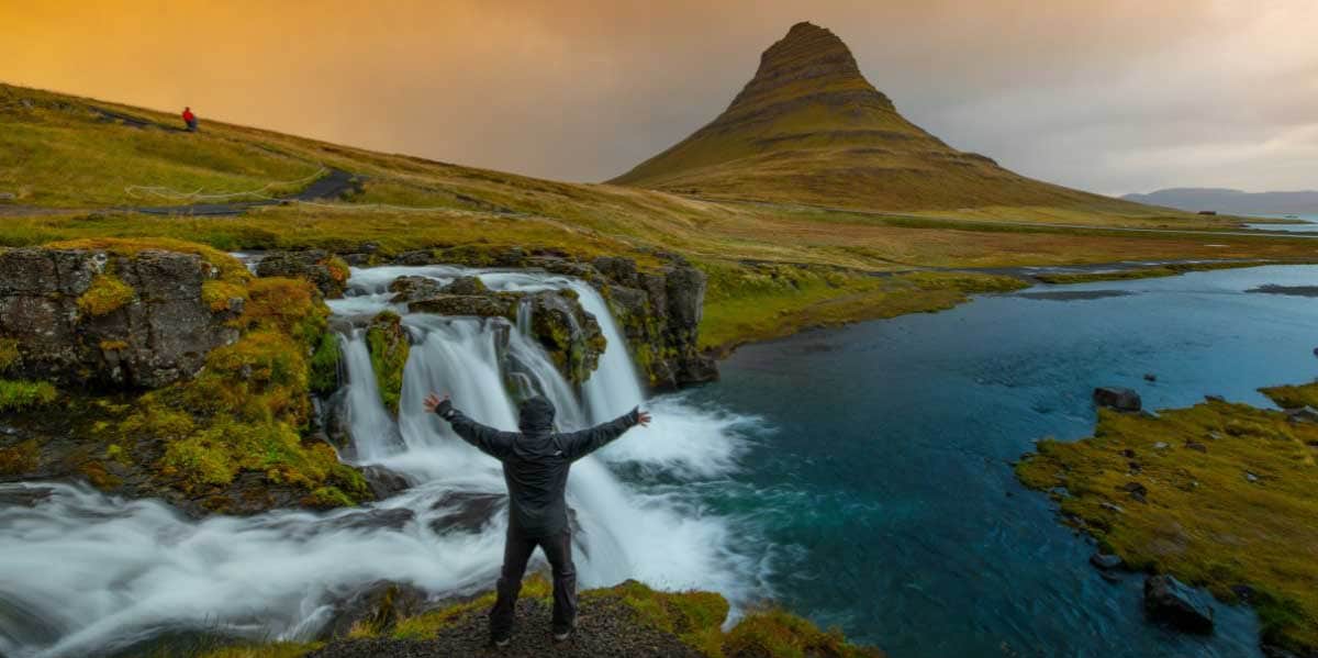
This mountain is in iceland and I take this opportunity to say that Iceland has incredibly beautiful landscapes. If you like nature that takes your breath away, I would schedule a trip right now. She is known as the "church mountain" and it's on the north coast of Iceland, close to the town of Grundarfjörour, just a two-hour drive from the national capital.
It is best to get to know it by doing the complete tour of the Snaefellsnes Peninsula, and if you hire a package, it is sure to be included because it is said that It is the most photographed mountain in the country. The mountain then has 463 meters and his figure cut out in the sky has always served as a guide and mark for travelers by land and sea. At the foot of the mountain there is a lake which, on clear days, beautifully reflects Mt.
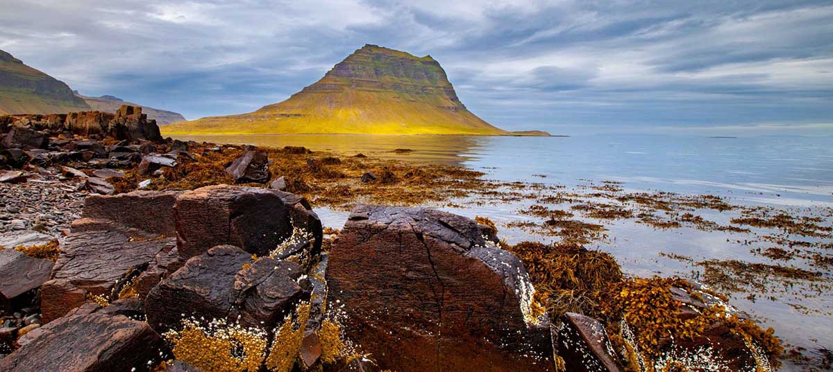
Also, it is a mountain that changes color according to the season: Green in summer, brown and white in winter and really impressive on days when the midnight sun shines, around the June equinox. And not to mention under the spooky northern lights! Between September and April.
Nearby, a gentle walk away, are the Kirkjufellsfoss waterfalls. These waterfalls have three small jumps and a gentle current, but the difference in height between them is the best thing about it. If you are interested in climbing, it is possible to do so and enjoy good views, both on the mountain and at the waterfalls.
Finally, a fact: the mountain appears in season 7 of Game of Thrones, in the episode "Behind the Wall".
Cliffs of Moher
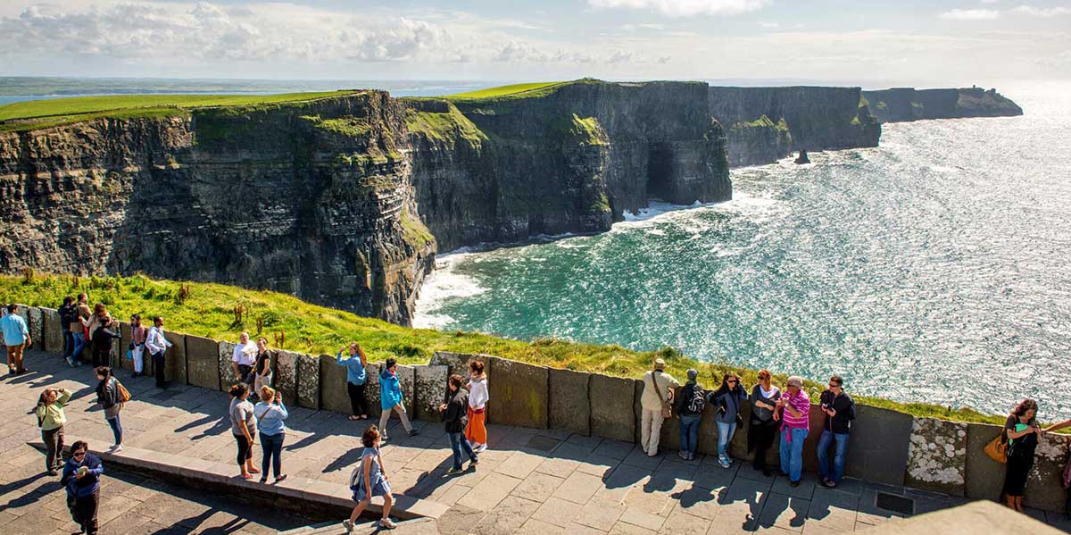
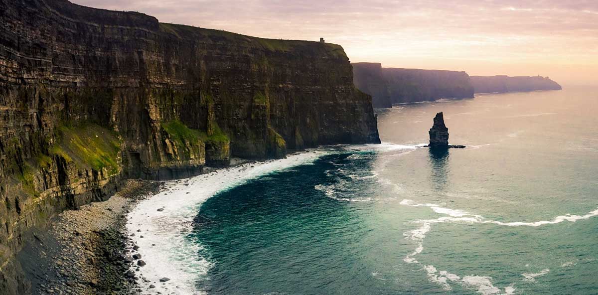
This beautiful and impressive landscape is in ireland and forms part of the general landscape of the Burren. They look at the Atlantic and run along the coast for 14 kilometers. according to geology formed about 320 million years ago and today UNESCO has them included in the Burren Global Geopark.
They are the most famous cliffs in the country and are also among the most famous in the world. You can sign up for the Cliffs of Moher Experience, a whole day is spent here, and children do not pay admission. There is a 800 meter network of trails safe and paved that allow you to enjoy the scenery, see the Aran Islands, Galway Bay and Maamtaurks in the distance and even Kerry in the distance.
many are offered guided tours, to learn about the history of the cliffs and the area itself, the west coast of Ireland, near the village of Liscannor, in County Clare. You can get there by car, by bus, by bike, motorcycle or by car. Or walking, too.
To make the visit a good day you can always visit the official website that includes the weather forecast and allows you to organize yourself better. It is also a good idea to visit the cliffs outside of rush hour, and obviously, at sunrise and sunset the landscape is special.
You can pay full admission, which includes a visit to the Visitor Center and the virtual reality exhibition and theater, plus a walk through the trails and access to the O'Brien Tower and its terrace, an audio guide, maps and information . All for 7 euros.
Hallstatt
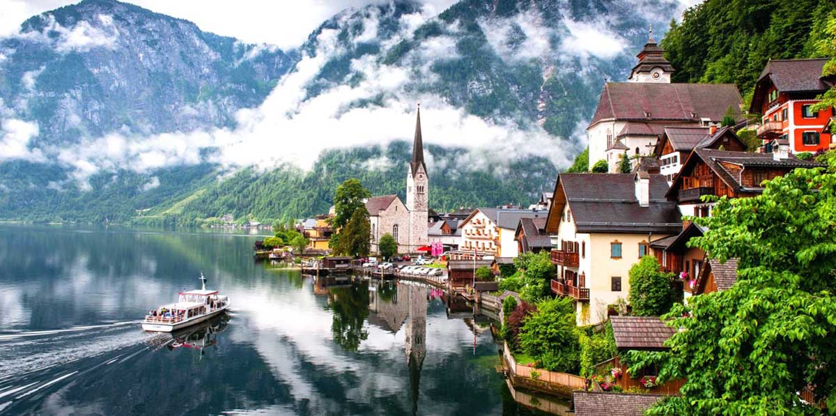
This lake landscape is in Austria and it's postcard. It is in the mountainous district of Salzkammergut, next to Lake Hallstatt and close to some fabulous salt mines. Until the XNUMXth century it could only be reached by boat or by very uncomfortable mountain paths, but everything began to change at the end of the XNUMXth century with the construction of a route that was cut through the rock of the mountain itself.
The place is beautiful. The village has a lovely square with a fountain in the middle, some Ancient churches, in Gothic and neo-Gothic style, a beautiful ossuary with 1200 skulls, a XNUMXth-century tower where a restaurant now operates, the lake itself, which is charming and full of fish, there are also waterfalls and among the newest and tourist counts the 5 Fingers Lookout, with transparent ground and shaped like fingers emerging from the mountain.
Finally, the visit to the Salt Mines You can not miss. She is said to be the oldest salt mine in the world because it already has seven thousand years of exploitation. You can get there on foot or by funicular and there is a museum inside.
Plitvice Lakes
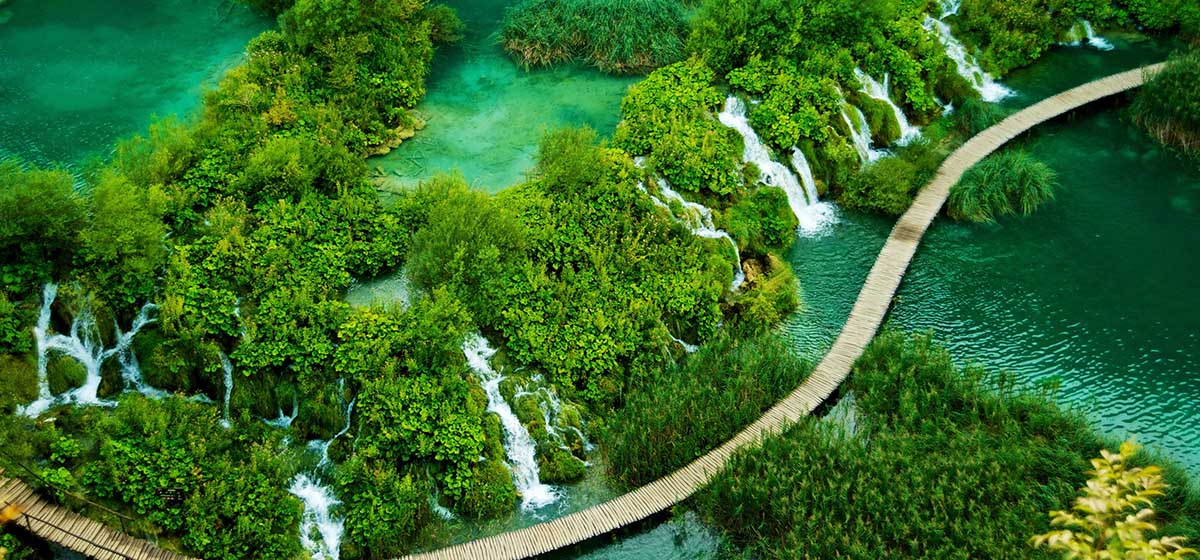
These fabulous lakes are in croatia and form a national park that is the oldest national park in the country. UNESCO has also included them in its list of World Heritageyes The lakes are in a karst area in the center of the country, right on the border with Bosnia and Herzegovina.
The protected area has almost 300 thousand square kilometers, with its lakes and waterfalls. are counted 16 lakes in total whose formation is the result of the confluence of several surface streams and rivers but also underground. In turn, the lakes are connected and follow the flow of water. Among them are separated by natural travertine dams, deposited there by algae, mold and bacteria over the centuries.
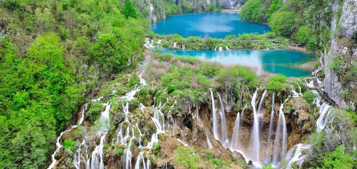
These natural prey are very delicate and almost alive, interacting all the time with air, water and plants. That is why they are always growing. It can be said that the total of the lakes is separated into two sectors, one high and one low. descending from an altitude of 636 meters to 503 meters over a distance of 8 kilometers. The Korona River is formed by the water that comes out of the lake at a lower altitude.
And yes, these Croatian lakes they are famous for their shapes and colors, green, blue, turquoise, the colors always change depending on the amount of minerals in the water and depending on the sunlight. The lakes are, in turn, about 55 kilometers from the Adriatic Sea and the coastal city of Senj.
Uyuni Salt Flats
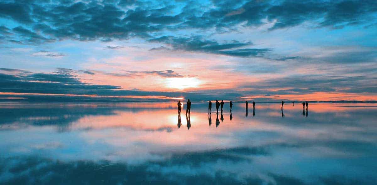
South America has incredible landscapes and one of them is in the small state of Bolivia. In this huge salt desert, the highest in the world, with little more than 10 thousand 500 square meters of surface.
The salt flat rests at 3650 meters and is in the Bolivian province of Daniel Campos, in the department of Potosi, in the highlands of the Andes. 40 thousand years ago there was a lake here, Lake Minchín, later there was another lake, and finally the climate stopped being humid and became dry and warm, producing the salt flat.

It seems that the salt contains about 10 million tons of salt and 25 thousand tons are extracted every year. But today salt is not the only important thing, Uyuni also has lithium and lithium is essential for the batteries of all our technological devices. In addition, it is used to calibrate satellites because it is five times better than the ocean for the same purpose.
The salar has a thickness that varies between less than one meter and ten meters and the total depth of it is 120 meters, between brine and mud. It is this brine that has boron, potassium, magnesium, sodium and lithium, among others.
Of course, it is one of the most popular tourist destinations in Bolivia and without a pandemic about 300 thousand people visit it every year.